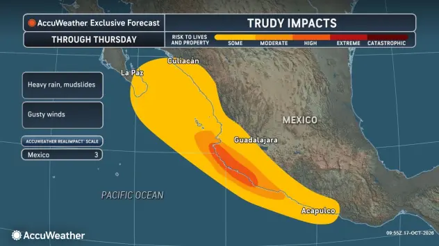
Hurricane Trudy is closing in on Mexico's Pacific coast. The map above tracks it live: its current position and strength, the official forecast cone, coastal watches and warnings, and a looping satellite and radar view. It updates on its own as new data comes in.
Where Trudy is now
As of the National Hurricane Center's noon Central advisory on Saturday:
- Location: about 140 miles south of Manzanillo and 290 miles west of Acapulco
- Winds: 90 mph, a Category 1 hurricane, with higher gusts
- Movement: northwest at 10 mph
- Pressure: 979 mb
Hurricane-force winds reach up to 35 miles from the center. Tropical-storm-force winds reach up to 140 miles.
The map always shows the latest numbers, so check it for anything newer than this.
Where it is going
The NHC expects Trudy to keep moving northwest, approaching the coast of southwestern and west-central Mexico on Saturday afternoon and passing near the coast Saturday night and Sunday.
Some strengthening is possible on Saturday. The NHC's forecast peaks Trudy at about 105 mph, Category 2, on Saturday night and Sunday morning. It then expects weakening from Sunday as the storm runs along the coast, dropping to a tropical storm by Monday evening.
An Air Force Reserve Hurricane Hunter aircraft was on its way to investigate the storm on Saturday.
Watches and warnings
- Hurricane warning: the coast from Manzanillo north to Cabo Corrientes. Hurricane conditions are expected by Saturday night.
- Hurricane watch: south of Manzanillo to Punta San Telmo.
- Tropical storm warning: south of Manzanillo to Zihuatanejo, and north of Cabo Corrientes to San Blas.
- Tropical storm watch: Las Islas Marías.
The NHC says more watches or warnings will likely be needed.
The biggest danger: rain
Wind gets the headlines, but rain is the main threat here.
The NHC expects 4 to 8 inches, with isolated totals near 12 inches, along and near the coast of Michoacán, Colima and Jalisco. On steep terrain, that can cause life-threatening flooding and mudslides. Outer bands could drop 2 to 4 inches, locally 6, on Guerrero and Nayarit.
Storm surge with large, destructive waves is possible near the coast where winds blow onshore. Swells are already causing life-threatening surf and rip currents along southwestern Mexico and will spread north.
If you are there
Follow Mexico's Servicio Meteorológico Nacional and local civil protection authorities. The NHC's own advice for the warning area: preparations to protect life and property should be rushed to completion.
This page updates automatically. Figures in the text are from the NHC's 12 p.m. CST advisory on Saturday, October 17, 2026; the live map shows the latest advisory. The next full NHC advisory is due at 3 p.m. CST.